
Thank you for supporting this site ❤️
Make a donation
Make a donation
Punta Hermosa topographic map
Click on the map to display elevation.
Thank you for supporting this site ❤️
Make a donation
Make a donation
About this map
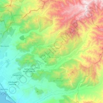
Name: Punta Hermosa topographic map, elevation, terrain.
Average elevation: 257 m
Minimum elevation: 0 m
Maximum elevation: 1,322 m
Thank you for supporting this site ❤️
Make a donation
Make a donation
Other topographic maps
Click on a map to view its topography, its elevation and its terrain.
Thank you for supporting this site ❤️
Make a donation
Make a donation
Thank you for supporting this site ❤️
Make a donation
Make a donation
Thank you for supporting this site ❤️
Make a donation
Make a donation
San Salvador de Pampas
Peru > Lima > Atavillos Bajo > San Salvador de Pampas
Average elevation: 3,323 m