
Thank you for supporting this site ❤️
Make a donation
Make a donation
Lahguia topographic map
Click on the map to display elevation.
Thank you for supporting this site ❤️
Make a donation
Make a donation
About this map
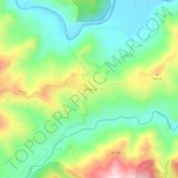
Name: Lahguia topographic map, elevation, terrain.
Location: Lahguia, Djebahia, Kadiria District, Bouira, Algeria (36.45534 3.66743 36.49534 3.70743)
Average elevation: 338 m
Minimum elevation: 171 m
Maximum elevation: 641 m
Thank you for supporting this site ❤️
Make a donation
Make a donation
Other topographic maps
Click on a map to view its topography, its elevation and its terrain.