
Thank you for supporting this site ❤️
Make a donation
Make a donation
Großaspach topographic map
Click on the map to display elevation.
Thank you for supporting this site ❤️
Make a donation
Make a donation
Großaspach
Aspach hat Anteil an den Naturräumen Schwäbisch-Fränkische Waldberge und Neckarbecken. Es liegt am Südrand der Löwensteiner Berge in 254 bis 516 Meter Höhe. Westlich des Ortsteils Kleinaspach liegt der Hardtwald.
Thank you for supporting this site ❤️
Make a donation
Make a donation
About this map
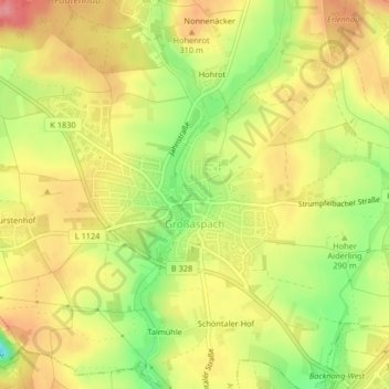
Name: Großaspach topographic map, elevation, terrain.
Average elevation: 293 m
Minimum elevation: 240 m
Maximum elevation: 333 m
Thank you for supporting this site ❤️
Make a donation
Make a donation
Other topographic maps
Click on a map to view its topography, its elevation and its terrain.
Rietenau
Deutschland > Baden-Württemberg > Rems-Murr-Kreis > Aspach > Rietenau
Average elevation: 331 m