
Thank you for supporting this site ❤️
Make a donation
Make a donation
Mount Chamah topographic map
Click on the map to display elevation.
Thank you for supporting this site ❤️
Make a donation
Make a donation
About this map
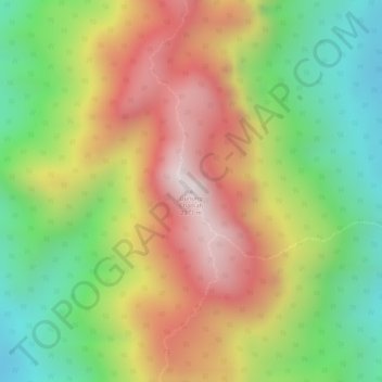
Name: Mount Chamah topographic map, elevation, terrain.
Location: Mount Chamah, Gua Musang, Kelantan, Malaysia (5.22717 101.57391 5.22727 101.57401)
Average elevation: 1,810 m
Minimum elevation: 1,479 m
Maximum elevation: 2,145 m
Thank you for supporting this site ❤️
Make a donation
Make a donation
Other topographic maps
Click on a map to view its topography, its elevation and its terrain.
Thank you for supporting this site ❤️
Make a donation
Make a donation
Thank you for supporting this site ❤️
Make a donation
Make a donation