
Thank you for supporting this site ❤️
Make a donation
Make a donation
Selsoif topographic map
Click on the map to display elevation.
Thank you for supporting this site ❤️
Make a donation
Make a donation
About this map
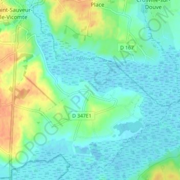
Name: Selsoif topographic map, elevation, terrain.
Average elevation: 11 m
Minimum elevation: -4 m
Maximum elevation: 40 m
Thank you for supporting this site ❤️
Make a donation
Make a donation
Other topographic maps
Click on a map to view its topography, its elevation and its terrain.
Voie Verte
France > Normandie > Manche > Saint-Sauveur-le-Vicomte > Les Closerons
Average elevation: 23 m