
Thank you for supporting this site ❤️
Make a donation
Make a donation
Obercallenberg topographic map
Click on the map to display elevation.
Thank you for supporting this site ❤️
Make a donation
Make a donation
About this map
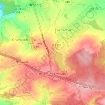
Name: Obercallenberg topographic map, elevation, terrain.
Average elevation: 357 m
Minimum elevation: 269 m
Maximum elevation: 412 m
Thank you for supporting this site ❤️
Make a donation
Make a donation
Other topographic maps
Click on a map to view its topography, its elevation and its terrain.
Stausee Oberwald
Deutschland > Sachsen > Zwickau > Callenberg > Obercallenberg
An der Nordseite des Tagebaus wurde ein Steinschüttdamm mit einer Höhe von 5,6 m und einer Kronenlänge von 250 m aus etwa 25.000 m³ Abraummassen und 5.000 t Schotter errichtet. Die Wasserseite wurde mit einer Betonabdichtung versehen. Es erfolgte die Einleitung der Quellbäche des Erlbachs aus dem Oberwald…
Average elevation: 371 m
Thank you for supporting this site ❤️
Make a donation
Make a donation