
Westliches Ringgebiet topographic map
Interactive map
Click on the map to display elevation.
About this map
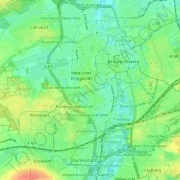
Name: Westliches Ringgebiet topographic map, elevation, terrain.
Location: Westliches Ringgebiet, Brunswick, Basse-Saxe, Allemagne (52.22805 10.47095 52.28354 10.52462)
Average elevation: 81 m
Minimum elevation: 66 m
Maximum elevation: 106 m
Other topographic maps
Click on a map to view its topography, its elevation and its terrain.
Lehndorf-Watenbüttel
Allemagne > Basse-Saxe > Brunswick > Watenbüttel
Lehndorf-Watenbüttel, Watenbüttel, Brunswick, Basse-Saxe, 38112, Allemagne
Average elevation: 73 m