
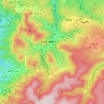
Bad Herrenalb topographic map
Interactive map
Click on the map to display elevation.
About this map
Name: Bad Herrenalb topographic map, elevation, terrain.
Average elevation: 574 m
Minimum elevation: 224 m
Maximum elevation: 947 m
Other topographic maps
Click on a map to view its topography, its elevation and its terrain.
Bad Liebenzell
Duitsland > Baden-Württemberg > Landkreis Calw
Bad Liebenzell, Verwaltungsgemeinschaft Bad Liebenzell, Landkreis Calw, Baden-Württemberg, 75378, Duitsland
Average elevation: 534 m
Haiterbach
Duitsland > Baden-Württemberg > Landkreis Calw
Haiterbach, Verwaltungsgemeinschaft Nagold, Landkreis Calw, Baden-Württemberg, 72221, Duitsland
Average elevation: 563 m