
Thank you for supporting this site ❤️
Make a donation
Make a donation
Thida topographic map
Click on the map to display elevation.
Thank you for supporting this site ❤️
Make a donation
Make a donation
About this map
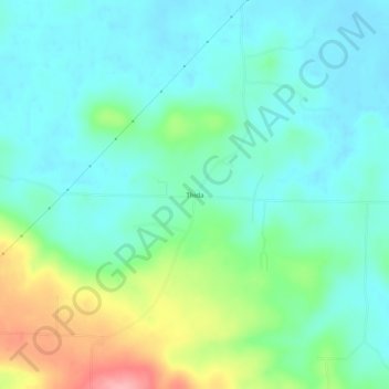
Name: Thida topographic map, elevation, terrain.
Location: Thida, Independence County, Arkansas, 72165, United States (35.55119 -91.49902 35.59119 -91.45902)
Average elevation: 96 m
Minimum elevation: 64 m
Maximum elevation: 185 m
Thank you for supporting this site ❤️
Make a donation
Make a donation
Other topographic maps
Click on a map to view its topography, its elevation and its terrain.
Southside
United States > Arkansas > Independence County
The elevation of Southside is 354 feet (108 m).
Average elevation: 112 m
Thank you for supporting this site ❤️
Make a donation
Make a donation