
Thank you for supporting this site ❤️
Make a donation
Make a donation
American Fork topographic map
Click on the map to display elevation.
Thank you for supporting this site ❤️
Make a donation
Make a donation
American Fork
The elevation is 4,566 feet (1,392 m) above sea level.
Thank you for supporting this site ❤️
Make a donation
Make a donation
About this map
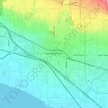
Name: American Fork topographic map, elevation, terrain.
Location: American Fork, Utah County, Utah, 84003, United States (40.33953 -111.83628 40.41170 -111.76361)
Average elevation: 1,405 m
Minimum elevation: 1,366 m
Maximum elevation: 1,555 m
Thank you for supporting this site ❤️
Make a donation
Make a donation
Other topographic maps
Click on a map to view its topography, its elevation and its terrain.
Thank you for supporting this site ❤️
Make a donation
Make a donation
Thank you for supporting this site ❤️
Make a donation
Make a donation
Thank you for supporting this site ❤️
Make a donation
Make a donation