
Thank you for supporting this site ❤️
Make a donation
Make a donation
Bremersheide topographic map
Click on the map to display elevation.
Thank you for supporting this site ❤️
Make a donation
Make a donation
Bremersheide
Bremersheide liegt östlich des Leichlinger Zentrums auf einem Höhenrücken zwischen dem Murbach und dem Weltersbach nördlich der Landesstraße 294 nahe der Stadtgrenze zu Leverkusen und zu Burscheid. Nördlich grenzt der Ort an das Naturschutzgebiet Weltersbachtal. In Bremersheide zweigt die Kreisstraße K6 nach Sankt Heribert ab.
Thank you for supporting this site ❤️
Make a donation
Make a donation
About this map
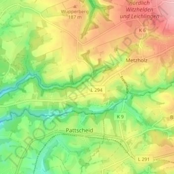
Name: Bremersheide topographic map, elevation, terrain.
Average elevation: 152 m
Minimum elevation: 80 m
Maximum elevation: 233 m
Thank you for supporting this site ❤️
Make a donation
Make a donation