
Thank you for supporting this site ❤️
Make a donation
Make a donation
Taro topographic map
Click on the map to display elevation.
Thank you for supporting this site ❤️
Make a donation
Make a donation
About this map
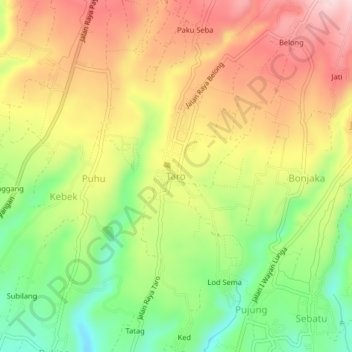
Name: Taro topographic map, elevation, terrain.
Location: Taro, Gianyar, Bali, Lesser Sunda Islands, 80572, Indonesia (-8.40621 115.26002 -8.36621 115.30002)
Average elevation: 612 m
Minimum elevation: 484 m
Maximum elevation: 736 m
Thank you for supporting this site ❤️
Make a donation
Make a donation
Other topographic maps
Click on a map to view its topography, its elevation and its terrain.