
Make a donation
Burke topographic map
Click on the map to display elevation.
Make a donation
About this map
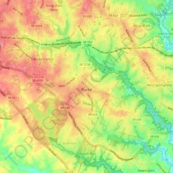
Name: Burke topographic map, elevation, terrain.
Location: Burke, Fairfax County, Virginia, 22015, United States (38.74530 -77.32718 38.81153 -77.22685)
Average elevation: 97 m
Minimum elevation: 50 m
Maximum elevation: 136 m
Make a donation
Other topographic maps
Click on a map to view its topography, its elevation and its terrain.
Make a donation
George Washington's Mount Vernon
United States > Virginia > Fairfax County > Mount Vernon
Average elevation: 14 m
Great Falls
United States > Virginia > Fairfax County
Great Falls is located at 38°59′53″N 077°17′18″W / 38.99806°N 77.28833°W / 38.99806; -77.28833 (38.9981653, −77.2883157) at an elevation of 344 feet (105 m). Located on Virginia State Route 7 in Northern Virginia, Great Falls is 15 miles (24 km) west-northwest of downtown Washington,…
Average elevation: 90 m
Make a donation
Make a donation
Barkers Crossroads
United States > Virginia > Fairfax County > West Springfield
Average elevation: 72 m
Make a donation
Cabell's Mill at Ellanor C. Lawerence Park
United States > Virginia > Fairfax County
Average elevation: 97 m
Make a donation
Salona Village
United States > Virginia > Fairfax County > Langley > Salona Village
Average elevation: 81 m
Battle of Blackburn's Ford (1861)
United States > Virginia > Fairfax County > Comptons Corner
Average elevation: 60 m
Belle Haven Park
United States > Virginia > Fairfax County > Alexandria > Westgrove
Average elevation: 8 m
Make a donation
Madrillon Farms
United States > Virginia > Fairfax County > Tysons > Madrillon Farms
Average elevation: 130 m
Make a donation