
Make a donation
Tuzla topographic map
Click on the map to display elevation.
Make a donation
About this map
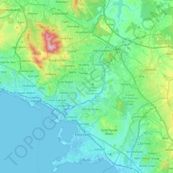
Name: Tuzla topographic map, elevation, terrain.
Location: Tuzla, Istanbul, Marmara Region, Turkey (40.80270 29.25458 40.98063 29.45682)
Average elevation: 102 m
Minimum elevation: -4 m
Maximum elevation: 532 m
Make a donation
Other topographic maps
Click on a map to view its topography, its elevation and its terrain.
Mount Ararat
Mount Ararat (/ˈærəræt/, ARR-ə-rat; Armenian: Արարատ, romanized: Ararat), also known as Mount Ağrı (Turkish: Ağrı Dağı) or Masis (Armenian: Մասիս), is a snow-capped and dormant compound volcano in eastern Turkey. It consists of two major volcanic cones: Greater Ararat and Little Ararat.…
Average elevation: 4,582 m
Make a donation
Ankara
Ankara has a cold semi-arid climate (Köppen climate classification: BSk). Under the Trewartha climate classification, Ankara has a temperate humid continental climate (Dc). Due to its elevation and inland location, Ankara has cold and snowy winters, and hot and dry summers. Rainfall occurs mostly during the…
Average elevation: 1,082 m
Make a donation
Make a donation