
Qingyuan City topographic map
Interactive map
Click on the map to display elevation.
Qingyuan City
Qingyuan's administrative area ranges in latitude from 23° 26' 56" to 25° 11' 40" N, and in longitude from 111° 55' 17" to 113° 55' 34" E; its urban area is located just north of the Tropic of Cancer, about 60 km (37 mi) from the urban area of Guangzhou and 200 km (120 mi) from both Hong Kong and Macau. Its area of over 19,000 km2 (7,300 sq mi) accounts for 10.6% of the total provincial area. Qingyuan contains part of the southern Nan Ling, and more than half of the area is mountainous, and elevations increase from southeast to northwest. Bordering prefectures are Guangzhou and Foshan to the southeast, Zhaoqing to the southwest, Shaoguan to the north and northeast, Hezhou (Guangxi) to the west, and Yongzhou and Chenzhou (Hunan) to the north.
About this map
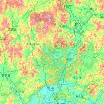
Name: Qingyuan City topographic map, elevation, terrain.
Location: Qingyuan City, Guangdong Province, China (23.45030 111.92230 25.19432 113.92617)
Average elevation: 349 m
Minimum elevation: 2 m
Maximum elevation: 1,830 m
Other topographic maps
Click on a map to view its topography, its elevation and its terrain.