
Thank you for supporting this site ❤️
Make a donation
Make a donation
El Tarf topographic map
Click on the map to display elevation.
Thank you for supporting this site ❤️
Make a donation
Make a donation
About this map
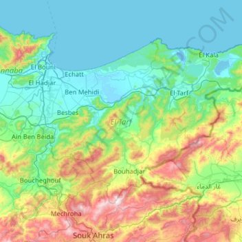
Name: El Tarf topographic map, elevation, terrain.
Location: El Tarf, Algeria (36.39108 7.65839 36.95204 8.68113)
Average elevation: 288 m
Minimum elevation: -3 m
Maximum elevation: 1,389 m
Thank you for supporting this site ❤️
Make a donation
Make a donation
Other topographic maps
Click on a map to view its topography, its elevation and its terrain.