
Kantabrien topographic map
Interactive map
Click on the map to display elevation.
About this map
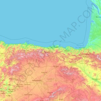
Name: Kantabrien topographic map, elevation, terrain.
Location: Kantabrien, Spanien (40.55957 -6.68784 45.75957 -1.48784)
Average elevation: 450 m
Minimum elevation: -1 m
Maximum elevation: 2,423 m
Other topographic maps
Click on a map to view its topography, its elevation and its terrain.
Santander
Spanien > Kantabrien > Santander
Santander, Comarca de Santander, Cantabria, Kantabrien, Spanien
Average elevation: 10 m
El Astillero
Spanien > Kantabrien > El Astillero
El Astillero, Comarca de Santander, Cantabria, Kantabrien, Spanien
Average elevation: 26 m
Río Negro
Spanien > Kantabrien > Escalante
Río Negro, Escalante, Trasmiera, Cantabria, Kantabrien, 39795, Spanien
Average elevation: 51 m