
Thank you for supporting this site ❤️
Make a donation
Make a donation
Gambela topographic map
Click on the map to display elevation.
Thank you for supporting this site ❤️
Make a donation
Make a donation
Gambela
Gambela (Amharic: ጋምቤላ), also spelled Gambella, is a city and separate woreda in Ethiopia and the capital of the Gambela Region. Located in Anyuak Zone, at the confluence of the Baro River and its tributary the Jajjabe, the city has a latitude and longitude of 8°15′N 34°35′E / 8.250°N 34.583°E / 8.250; 34.583 and an elevation of 526 meters. It is surrounded by Gambella Zuria.
Thank you for supporting this site ❤️
Make a donation
Make a donation
About this map
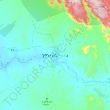
Name: Gambela topographic map, elevation, terrain.
Location: Gambela, Agnuak, Gambela Region, Ethiopia (8.09037 34.42773 8.41037 34.74773)
Average elevation: 570 m
Minimum elevation: 429 m
Maximum elevation: 1,430 m
Thank you for supporting this site ❤️
Make a donation
Make a donation
Other topographic maps
Click on a map to view its topography, its elevation and its terrain.