
Thank you for supporting this site ❤️
Make a donation
Make a donation
Bongseong-ri topographic map
Click on the map to display elevation.
Thank you for supporting this site ❤️
Make a donation
Make a donation
About this map
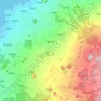
Name: Bongseong-ri topographic map, elevation, terrain.
Location: Bongseong-ri, Aewol, Jeju, 63039, South Korea (33.34104 126.30201 33.43139 126.44923)
Average elevation: 255 m
Minimum elevation: 0 m
Maximum elevation: 737 m
Thank you for supporting this site ❤️
Make a donation
Make a donation