
Thank you for supporting this site ❤️
Make a donation
Make a donation
Schooleys Mountain topographic map
Click on the map to display elevation.
Thank you for supporting this site ❤️
Make a donation
Make a donation
About this map
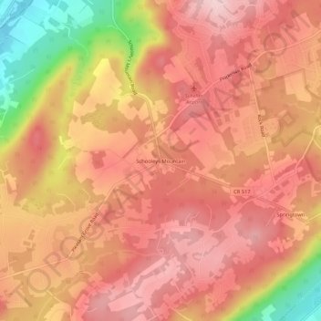
Name: Schooleys Mountain topographic map, elevation, terrain.
Average elevation: 293 m
Minimum elevation: 141 m
Maximum elevation: 362 m
Thank you for supporting this site ❤️
Make a donation
Make a donation
Other topographic maps
Click on a map to view its topography, its elevation and its terrain.
Long Valley
United States > New Jersey > Morris County > Washington Township > Long Valley
Average elevation: 235 m