
Make a donation
Snowmass Village topographic map
Click on the map to display elevation.
Make a donation
About this map
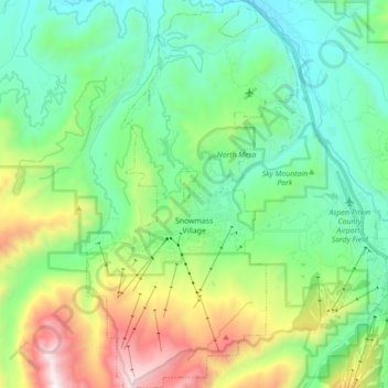
Name: Snowmass Village topographic map, elevation, terrain.
Average elevation: 2,675 m
Minimum elevation: 2,191 m
Maximum elevation: 3,922 m
Make a donation
Other topographic maps
Click on a map to view its topography, its elevation and its terrain.
Make a donation
Capitol Peak
United States > Colorado > Pitkin County
At the trail head, at an altitude of 9,400 feet, following several switchbacks for half a mile will lead you to Daly Pass. Daly Pass is the first point of interest on Capitol Peak. This pass is recognized for its saddle-shaped ridge reaching 12,480 feet.
Average elevation: 3,750 m
Make a donation
Maroon Bells
United States > Colorado > Pitkin County
Maroon Lake, elevation 2,920 m (9,580 ft), occupies a basin that was sculpted by Ice Age glaciers and later dammed by a landslide and rockfall debris from the steep slopes above the valley floor.
Average elevation: 3,691 m