
Make a donation
Roydon topographic map
Click on the map to display elevation.
Make a donation
About this map
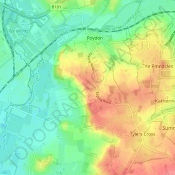
Name: Roydon topographic map, elevation, terrain.
Location: Roydon, Epping Forest, Essex, England, United Kingdom (51.74022 0.00212 51.77989 0.07572)
Average elevation: 48 m
Minimum elevation: 19 m
Maximum elevation: 89 m
Make a donation
Other topographic maps
Click on a map to view its topography, its elevation and its terrain.
Make a donation
Nazeing Gate
United Kingdom > England > Essex > Epping Forest > Bumble's Green > Nazeing
Average elevation: 70 m
Roughtalley's Wood (South) & Epping Forest Woodland Burial Ground
United Kingdom > England > Essex > Epping Forest > Coopersale
Average elevation: 96 m
Make a donation
Passingford Bridge
United Kingdom > England > Essex > Epping Forest > Stapleford Tawney
Average elevation: 53 m
Make a donation
Thornwood Common
United Kingdom > England > Essex > Epping Forest > Thornwood Common
Average elevation: 89 m
Make a donation
Steward's Green
United Kingdom > England > Essex > Epping Forest > Coopersale Street > Steward's Green
Average elevation: 76 m
Make a donation
How Green
United Kingdom > England > Essex > Epping Forest > Stapleford Abbotts
Average elevation: 63 m
Make a donation
Passingford Bridge
United Kingdom > England > Essex > Epping Forest > Stapleford Tawney
Average elevation: 53 m