
Thank you for supporting this site ❤️
Make a donation
Make a donation
Coon Rapids topographic map
Click on the map to display elevation.
Thank you for supporting this site ❤️
Make a donation
Make a donation
About this map
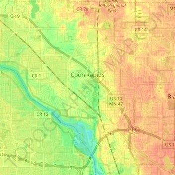
Name: Coon Rapids topographic map, elevation, terrain.
Location: Coon Rapids, Anoka County, Minnesota, United States (45.11871 -93.37356 45.21292 -93.26573)
Average elevation: 268 m
Minimum elevation: 245 m
Maximum elevation: 283 m
Thank you for supporting this site ❤️
Make a donation
Make a donation
Other topographic maps
Click on a map to view its topography, its elevation and its terrain.
Rum River North County Park
United States > Minnesota > Anoka County > Saint Francis
Average elevation: 279 m
Thank you for supporting this site ❤️
Make a donation
Make a donation