
Thank you for supporting this site ❤️
Make a donation
Make a donation
Sierra de Ojete-Chite topographic map
Click on the map to display elevation.
Thank you for supporting this site ❤️
Make a donation
Make a donation
About this map
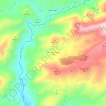
Name: Sierra de Ojete-Chite topographic map, elevation, terrain.
Average elevation: 666 m
Minimum elevation: 453 m
Maximum elevation: 936 m
Thank you for supporting this site ❤️
Make a donation
Make a donation
Other topographic maps
Click on a map to view its topography, its elevation and its terrain.
Sierra de las Chanzas
España > Andalucía > Partido Judicial de Loja > Algarinejo
Average elevation: 904 m