
Thank you for supporting this site ❤️
Make a donation
Make a donation
Ostend topographic map
Click on the map to display elevation.
Thank you for supporting this site ❤️
Make a donation
Make a donation
About this map
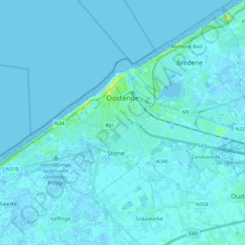
Name: Ostend topographic map, elevation, terrain.
Location: Ostend, West Flanders, Flanders, 8400, Belgium (51.18459 2.83846 51.24607 3.00431)
Average elevation: 1 m
Minimum elevation: -3 m
Maximum elevation: 24 m
Thank you for supporting this site ❤️
Make a donation
Make a donation
Other topographic maps
Click on a map to view its topography, its elevation and its terrain.