
Make a donation
Dechmont topographic map
Click on the map to display elevation.
Make a donation
About this map
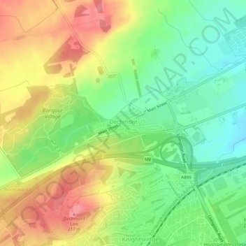
Name: Dechmont topographic map, elevation, terrain.
Location: Dechmont, West Lothian, Scotland, United Kingdom (55.91916 -3.54538 55.92296 -3.52878)
Average elevation: 155 m
Minimum elevation: 111 m
Maximum elevation: 207 m
Make a donation
Other topographic maps
Click on a map to view its topography, its elevation and its terrain.
Bathgate
United Kingdom > Scotland > West Lothian
In the 1846 book A Topographical Dictionary of Scotland, Samuel Lewis writes.
Average elevation: 167 m
Make a donation
Make a donation
Make a donation
Make a donation
Make a donation
Make a donation
Make a donation
Armadale
United Kingdom > Scotland > West Lothian
Aside from the presence of the old castle, Armadale was little more than a rural farm community for most of its history, as part of a larger rural estate named Barbauchlaw (a corruption of 'Boar Baughlee'). However, this situation changed with the coming of the new turnpike road between Edinburgh and Glasgow…
Average elevation: 166 m
Make a donation
Bathgate
United Kingdom > Scotland > West Lothian
In the 1846 book A Topographical Dictionary of Scotland, Samuel Lewis writes.
Average elevation: 167 m
Make a donation