
Thank you for supporting this site ❤️
Make a donation
Make a donation
Pithapuram topographic map
Click on the map to display elevation.
Thank you for supporting this site ❤️
Make a donation
Make a donation
Pithapuram
Pitapuram is located at 17°07′00″N 82°16′00″E / 17.1167°N 82.2667°E / 17.1167; 82.2667. It has an average elevation of 10 meters (33 feet). The town is approximately 20 kilometres from the district headquarters, Kakinada, and 75 kilometres from Rajahmundry. In 1957, Pitapuram was designated as a 2nd grade Municipality and an urban local body (ULB). It is spread over an area of 19.57 square kilometres.
Thank you for supporting this site ❤️
Make a donation
Make a donation
About this map
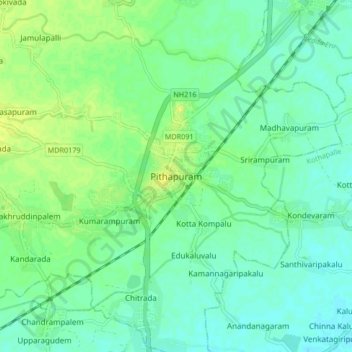
Name: Pithapuram topographic map, elevation, terrain.
Location: Pithapuram, Kakinada, Andhra Pradesh, 533450, India (17.07334 82.21433 17.15334 82.29433)
Average elevation: 13 m
Minimum elevation: 6 m
Maximum elevation: 24 m
Thank you for supporting this site ❤️
Make a donation
Make a donation