
Thank you for supporting this site ❤️
Make a donation
Make a donation
Guys Mills topographic map
Click on the map to display elevation.
Thank you for supporting this site ❤️
Make a donation
Make a donation
About this map
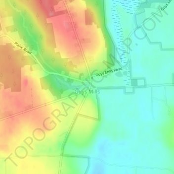
Name: Guys Mills topographic map, elevation, terrain.
Location: Guys Mills, Crawford County, Pennsylvania, United States (41.62673 -79.98391 41.63473 -79.96852)
Average elevation: 429 m
Minimum elevation: 398 m
Maximum elevation: 480 m
Thank you for supporting this site ❤️
Make a donation
Make a donation
Other topographic maps
Click on a map to view its topography, its elevation and its terrain.
Espyville
United States > Pennsylvania > Crawford County > Pymatuning Central
Average elevation: 319 m