
Redwood topographic map
Interactive map
Click on the map to display elevation.
About this map
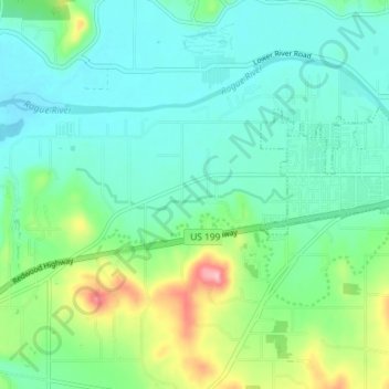
Name: Redwood topographic map, elevation, terrain.
Location: Redwood, Josephine County, Oregon, United States (42.40071 -123.42082 42.43844 -123.34845)
Average elevation: 300 m
Minimum elevation: 260 m
Maximum elevation: 422 m
Other topographic maps
Click on a map to view its topography, its elevation and its terrain.
Grants Pass
United States > Oregon > Josephine County
Grants Pass, Josephine County, Oregon, United States
Average elevation: 374 m
Cave Junction
United States > Oregon > Josephine County
Cave Junction, Josephine County, Oregon, United States
Average elevation: 410 m
Wilderville
United States > Oregon > Josephine County
Wilderville, Josephine County, Oregon, United States
Average elevation: 364 m
O'Brien
United States > Oregon > Josephine County
O'Brien, Josephine County, Oregon, 97534, United States
Average elevation: 454 m
Sunny Valley
United States > Oregon > Josephine County
Sunny Valley, Josephine County, Oregon, 97497, United States
Average elevation: 476 m
Fruitdale
United States > Oregon > Josephine County > Grants Pass
Fruitdale, Grants Pass, Josephine County, Oregon, 97506, United States
Average elevation: 346 m
Grants Pass
United States > Oregon > Josephine County
Grants Pass, Josephine County, Oregon, United States
Average elevation: 377 m
Williams
United States > Oregon > Josephine County
Williams, Josephine County, Oregon, 97544, United States
Average elevation: 484 m
Merlin
United States > Oregon > Josephine County
Merlin, Josephine County, Oregon, 57526, United States
Average elevation: 308 m
Galice
United States > Oregon > Josephine County > Galice
Galice, Josephine County, Oregon, United States
Average elevation: 402 m
Wolf Creek
United States > Oregon > Josephine County
Wolf Creek, Josephine County, Oregon, 97497, United States
Average elevation: 522 m