
Bath topographic map
Click on the map to display elevation.
Bath
Bath is in the Avon Valley and is surrounded by limestone hills as it is near the southern edge of the Cotswolds, a designated Area of Outstanding Natural Beauty, and the limestone Mendip Hills rise around 7 miles (11 km) south of the city. The hills that surround and make up the city have a maximum altitude of 781 feet (238 metres) on the Lansdown plateau. Bath has an area of 11 square miles (28 square kilometres).
About this map
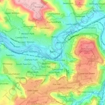
Name: Bath topographic map, elevation, terrain.
Average elevation: 100 m
Minimum elevation: 14 m
Maximum elevation: 235 m
Other topographic maps
Click on a map to view its topography, its elevation and its terrain.
Hallatrow
United Kingdom > England > Bath and North East Somerset > High Littleton
Average elevation: 119 m
Norton Hawkfield
United Kingdom > England > Bath and North East Somerset > Norton Malreward
Average elevation: 96 m
Knowle Hill
United Kingdom > England > Bath and North East Somerset > Chew Magna
Average elevation: 65 m
Little Solsbury Hill
United Kingdom > England > Bath and North East Somerset > Batheaston
Average elevation: 88 m
Monger
United Kingdom > England > Bath and North East Somerset > Midsomer Norton
Average elevation: 118 m
Park Corner
United Kingdom > England > Bath and North East Somerset > Freshford > Park Corner
Average elevation: 93 m
Bathwick Hill
United Kingdom > England > Bath and North East Somerset > Bath
Number 1 (Bathwick Lodge) is a 2-storey villa with a steep Mansard room, built in 1825, extended in 1840 and the late C19. Probably by John Pinch the Elder.[4] Number 2 is from the early 19th century and has shutters over the windows.[11] Number 3 includes a porch which is elaborately enriched with carving,…
Average elevation: 93 m
Sharpstone
United Kingdom > England > Bath and North East Somerset > Freshford
Average elevation: 93 m
Chewton Keynsham
United Kingdom > England > Bath and North East Somerset > Compton Dando
Average elevation: 57 m
North Wick
United Kingdom > England > Bath and North East Somerset > Chew Magna
Average elevation: 110 m
Carlingcott
United Kingdom > England > Bath and North East Somerset > Peasedown St. John
Average elevation: 123 m
Pipehouse
United Kingdom > England > Bath and North East Somerset > Hinton Charterhouse
Average elevation: 94 m
Keynsham Memorial Park
United Kingdom > England > Bath and North East Somerset > Keynsham
Average elevation: 29 m
Stoney Littleton
United Kingdom > England > Bath and North East Somerset > Shoscombe
Average elevation: 116 m
Clutton Hill
United Kingdom > England > Bath and North East Somerset > Farmborough
Average elevation: 133 m
Maes Knoll
United Kingdom > England > Bath and North East Somerset > Norton Malreward
Average elevation: 110 m
Wick Green
United Kingdom > England > Bath and North East Somerset > Bishop Sutton
Average elevation: 82 m
Whitley Batts
United Kingdom > England > Bath and North East Somerset > Pensford
Average elevation: 87 m
Monger
United Kingdom > England > Bath and North East Somerset > Midsomer Norton
Average elevation: 118 m