
Make a donation
Sioux Lookout topographic map
Click on the map to display elevation.
Make a donation
About this map
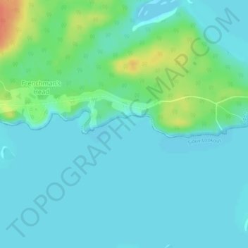
Name: Sioux Lookout topographic map, elevation, terrain.
Average elevation: 363 m
Minimum elevation: 353 m
Maximum elevation: 397 m
Make a donation
Other topographic maps
Click on a map to view its topography, its elevation and its terrain.
Lac Seul
Canada > Ontario > Kenora District
Lac Seul is a large, crescent shaped reservoir in Kenora District, northwestern Ontario, Canada. It is approximately 241 km (150 mi) long. It has a maximum (regulated) depth of 47.2 m, with a surface elevation of 357 m above sea level. Its level is raised in the summer and then drawn down in the winter months…
Average elevation: 388 m
Gibi Lake
Canada > Ontario > Kenora District > Sioux Narrows-Nestor Falls Township
Average elevation: 373 m
Make a donation
Nungesser Lake
Canada > Ontario > Kenora District > Unorganized Kenora District
Average elevation: 412 m
Make a donation
Sunlight Lake
Canada > Ontario > Kenora District > Unorganized Kenora District
Average elevation: 374 m
Sioux Narrows
Canada > Ontario > Kenora District > Sioux Narrows-Nestor Falls Township
Average elevation: 329 m
Make a donation