
Make a donation
Las Leñas topographic map
Click on the map to display elevation.
Make a donation
Las Leñas
Las Leñas is a ski resort in Argentina, located in the western part of Mendoza Province. It has reliable powder snow and climate for extreme and off-piste skiing. Construction of the ski center began January 1983, and by July 1983, it opened with a 300 bed hotel. The ski area has a good diversity of slopes ranging from very easy to extreme, including a good range of off-piste areas apt for extreme skiing. The skiable area base starts at an altitude of 2,240 m (7,350 feet) above mean sea level and goes up to 3,430 m (11,253 ft) for a total drop of 1,190 m (3,904 ft). The skiable surface amounts to 2.3 km2 (1 sq mi), with 27 runs and a maximum non-stop skiable distance of 7 km (4 mi) (not including off run alternatives). The total ski area reachable by land is the largest in South America. It currently houses Piscis Hotel, the highest casino by elevation in the world.
Make a donation
About this map
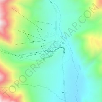
Name: Las Leñas topographic map, elevation, terrain.
Average elevation: 2,393 m
Minimum elevation: 2,115 m
Maximum elevation: 3,082 m
Make a donation
Other topographic maps
Click on a map to view its topography, its elevation and its terrain.