
Orford topographic map
Interactive map
Click on the map to display elevation.
About this map
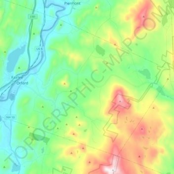
Name: Orford topographic map, elevation, terrain.
Location: Orford, Grafton County, New Hampshire, États-Unis d'Amérique (43.83795 -72.17370 43.95761 -71.96389)
Average elevation: 300 m
Minimum elevation: 111 m
Maximum elevation: 979 m
Other topographic maps
Click on a map to view its topography, its elevation and its terrain.
Canaan
États-Unis d'Amérique > New Hampshire > Grafton County > Canaan
Canaan, Grafton County, New Hampshire, 03741, États-Unis d'Amérique
Average elevation: 404 m
Mont Lafayette
États-Unis d'Amérique > New Hampshire > Grafton County > Franconia
Mont Lafayette, Franconia, Grafton County, New Hampshire, États-Unis d'Amérique
Average elevation: 1,224 m