
Thank you for supporting this site ❤️
Make a donation
Make a donation
Bad Lauterberg im Harz topographic map
Click on the map to display elevation.
Thank you for supporting this site ❤️
Make a donation
Make a donation
About this map
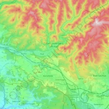
Name: Bad Lauterberg im Harz topographic map, elevation, terrain.
Average elevation: 387 m
Minimum elevation: 184 m
Maximum elevation: 716 m
Thank you for supporting this site ❤️
Make a donation
Make a donation
Other topographic maps
Click on a map to view its topography, its elevation and its terrain.
Kamschlacken
Germany > Lower Saxony > Landkreis Göttingen > Osterode am Harz > Riefensbeek-Kamschlacken
Average elevation: 513 m
Thank you for supporting this site ❤️
Make a donation
Make a donation
Zoll
Germany > Lower Saxony > Landkreis Göttingen > Bad Lauterberg im Harz > Barbis
Average elevation: 315 m