
Make a donation
Vila da Quixaba topographic map
Click on the map to display elevation.
Make a donation
About this map
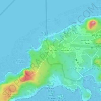
Name: Vila da Quixaba topographic map, elevation, terrain.
Average elevation: 31 m
Minimum elevation: -1 m
Maximum elevation: 225 m
Make a donation
Other topographic maps
Click on a map to view its topography, its elevation and its terrain.
Fernando de Noronha
Fernando de Noronha consists of 21 islands and islets, extending over an area of 26 square kilometres (10 sq mi). Only the eponymous main island is inhabited; it has an area of 18.4 square kilometres (7.1 sq mi) and a population estimated at 3,101 in 2020. While most of the archipelago is relatively low-lying,…
Average elevation: 9 m
Caruaru
The municipality lies within the Borborema Province geo-environmental unit, characterized by high massifs and hills with altitudes ranging from 600 to 1,000 meters. The relief is predominantly rugged, with deep and dissected valleys, and an average elevation of 554 meters above sea level. Located on the…
Average elevation: 535 m
Praça Farias Neves
Brazil > Pernambuco > Região Metropolitana do Recife > Recife
Average elevation: 22 m
Make a donation
Olinda
Brazil > Pernambuco > Região Metropolitana do Recife
The average elevation is 16 m above sea level. The landscapes is made of plains and hills, some of them steep. Olinda is mostly drained by the Paratibe River (55.13% of the territory), with the remainder drained by the Capibaribe River. The municipality is in the Atlantic Forest ecoregion.
Average elevation: 9 m
Petrolina
Brazil > Pernambuco > Região Administrativa Integrada de Desenvolvimento do Polo Petrolina e Juazeiro
Petrolina is situated on the left (northern) bank of the São Francisco River, in the interior semi-arid Sertão subregion, at an elevation of 376 m. On the other side of the river sits Juazeiro, in state of Bahia, and together the cities form an integrated metropolitan area. The two cities, making up an urban…
Average elevation: 420 m
Make a donation
Reserva Extrativista Acaú-Goiana
Brazil > Pernambuco > Região Metropolitana do Recife > Goiana
Average elevation: 39 m
Fernando de Noronha
Fernando de Noronha (Brazilian Portuguese pronunciation: [feʁˈnɐ̃du dʒi noˈɾoɲɐ]), officially the State District of Fernando de Noronha (Portuguese: Distrito Estadual de Fernando de Noronha) and formerly known as the Federal Territory of Fernando de Noronha (Território Federal de Fernando de Noronha)…
Average elevation: 9 m
Make a donation
Praça Bido Krause
Brazil > Pernambuco > Região Metropolitana do Recife > Recife
Average elevation: 25 m
Fernando de Noronha
Fernando de Noronha (Brazilian Portuguese pronunciation: [feʁˈnɐ̃du dʒi noˈɾoɲɐ]), officially the State District of Fernando de Noronha (Portuguese: Distrito Estadual de Fernando de Noronha) and formerly known as the Federal Territory of Fernando de Noronha (Território Federal de Fernando de Noronha)…
Average elevation: 9 m
Olinda
Brazil > Pernambuco > Região Metropolitana do Recife
The average elevation is 16 m above sea level. The landscapes is made of plains and hills, some of them steep. Olinda is mostly drained by the Paratibe River (55.13% of the territory), with the remainder drained by the Capibaribe River. The municipality is in the Atlantic Forest ecoregion.
Average elevation: 9 m
Make a donation
Make a donation
Make a donation
Olinda
Brazil > Pernambuco > Região Metropolitana do Recife
The average elevation is 16 m above sea level. The landscapes is made of plains and hills, some of them steep. Olinda is mostly drained by the Paratibe River (55.13% of the territory), with the remainder drained by the Capibaribe River. The municipality is in the Atlantic Forest ecoregion.
Average elevation: 9 m
Petrolina
Brazil > Pernambuco > Região Administrativa Integrada de Desenvolvimento do Polo Petrolina e Juazeiro
Petrolina is situated on the left (northern) bank of the São Francisco River, in the interior semi-arid Sertão subregion, at an elevation of 376 m. On the other side of the river sits Juazeiro, in state of Bahia, and together the cities form an integrated metropolitan area. The two cities, making up an urban…
Average elevation: 420 m
Make a donation
Gravatá
Gravatá is located at 08°12′04″S 35°33′53″W / 8.20111°S 35.56472°W / -8.20111; -35.56472. The average altitude is 447 metres (1,467 ft). The area of Gravatá is 491.53 km2 (189.78 sq mi). It is known for a pleasant climate (annual medium temperature 18 °C or 64.4 °F) and its charming…
Average elevation: 448 m
Make a donation
Orocó
Brazil > Pernambuco > Região Administrativa Integrada de Desenvolvimento do Polo Petrolina e Juazeiro
Average elevation: 379 m
Triunfo
Triunfo is a municipality in the Northeastern Brazilian state of Pernambuco. The estimated population in 2020, according to the Brazilian Institute of Geography and Statistics (IBGE) was 15,243. The area of the municipality is 191.52 km2, and in 2010 the population density was 78 inhabitants/km2. Triunfo sits…
Average elevation: 759 m
Make a donation
Make a donation
Make a donation
Floresta
Floresta is a city in the Brazilian state of Pernambuco. It is situated at latitude 08º36'04" south and at longitude 38º34'07" west, at an altitude of 316 metres. Its population was estimated in 2020 to be 33,184 inhabitants, according to the Brazilian Institute of Geography and Statistics. It has an area of…
Average elevation: 400 m
Make a donation
Make a donation
Santo Agostinho
Brazil > Pernambuco > Região Metropolitana do Recife > Cabo de Santo Agostinho
Average elevation: 19 m
Make a donation
Make a donation
Toritama
Toritama is a municipality in the Brazilian state of Pernambuco, in the mesoregion of Agreste Pernambucano. It is located at an altitude of 349 m, and it is 153 km west of the capital Recife. In 2020 it has an estimated population of 46,164 and an area of 25.7 km², which makes it the smallest municipality of…
Average elevation: 416 m
Make a donation
Jaqueira
Jaqueira is located in the Brazilian state of Pernambuco, in the coastal Zona da Mata region. The city is 147 kilometers away from the state's capital city of Recife. It is bound by the Lagoa dos Gatos to the north, Maraial to the south, Catende to the east, and São Benedito do Sul to the west. The city has…
Average elevation: 326 m
Make a donation
Ana de Alburquerque
Brazil > Pernambuco > Região Metropolitana do Recife > Igarassu
Average elevation: 17 m
Make a donation
Make a donation
Make a donation
Make a donation
Santa Maria da Boa Vista
Brazil > Pernambuco > Região Administrativa Integrada de Desenvolvimento do Polo Petrolina e Juazeiro
Average elevation: 401 m
Make a donation
Make a donation
Lagoa Grande
Brazil > Pernambuco > Região Administrativa Integrada de Desenvolvimento do Polo Petrolina e Juazeiro
Average elevation: 422 m
Make a donation
Make a donation