
Hatboro topographic map
Interactive map
Click on the map to display elevation.
About this map
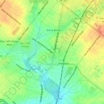
Name: Hatboro topographic map, elevation, terrain.
Average elevation: 77 m
Minimum elevation: 57 m
Maximum elevation: 98 m
Other topographic maps
Click on a map to view its topography, its elevation and its terrain.
Knight Lake
États-Unis d'Amérique > Pennsylvanie > Montgomery County > Upper Frederick Township
Knight Lake, Upper Frederick Township, Montgomery County, Pennsylvanie, États-Unis d'Amérique
Average elevation: 95 m
Perkiomen Place
États-Unis d'Amérique > Pennsylvanie > Montgomery County > East Greenville > Perkiomen Place
Perkiomen Place, East Greenville, Montgomery County, Pennsylvanie, 18041, États-Unis d'Amérique
Average elevation: 112 m