Geolocate

Gunung Mas topographic map

Interactive map

Click on the map to display elevation.

About this map

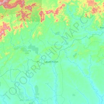
Name: Gunung Mas topographic map, elevation, terrain.

Location: Gunung Mas, Central Kalimantan, Kalimantan, Indonesia (-1.65498 113.15756 -0.29082 114.00800)

Average elevation: 152 m

Minimum elevation: 10 m

Maximum elevation: 1,309 m

Other topographic maps

Click on a map to view its topography, its elevation and its terrain.

Seruyan River

Indonesia > Central Kalimantan

Seruyan River, Central Kalimantan, Indonesia

Average elevation: 3 m

Seruyan River

Indonesia > Central Kalimantan

Seruyan River, Central Kalimantan, Indonesia

Average elevation: 4 m

Seruyan River

Indonesia > Central Kalimantan

Seruyan River, Central Kalimantan, Indonesia

Average elevation: 148 m

River

Indonesia > Central Kalimantan > Palangka Raya

River, Palangka Raya, Central Kalimantan, Indonesia

Average elevation: 4 m

Tandjung Puting

Indonesia > Central Kalimantan

Tandjung Puting, Central Kalimantan, Indonesia

Average elevation: 1 m

Jaar

Indonesia > Central Kalimantan > Jaar

Jaar, Central Kalimantan, Indonesia

Average elevation: 25 m

Sampit River

Indonesia > Central Kalimantan

Sampit River, Central Kalimantan, Indonesia

Average elevation: 15 m