
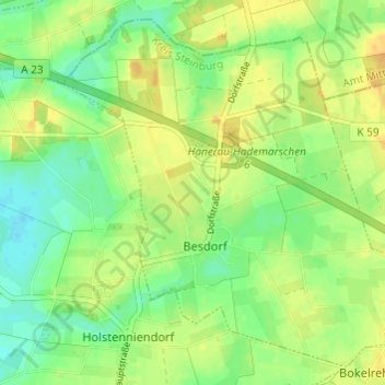
Besdorf topographic map
Interactive map
Click on the map to display elevation.
About this map
Name: Besdorf topographic map, elevation, terrain.
Average elevation: 14 m
Minimum elevation: -1 m
Maximum elevation: 26 m
Other topographic maps
Click on a map to view its topography, its elevation and its terrain.
Itzehoe
Deutschland > Schleswig-Holstein > Kreis Steinburg
Itzehoe, Nutteln, Kreis Steinburg, Schleswig-Holstein, 25524, Deutschland
Average elevation: 19 m
Hohenlockstedt
Deutschland > Schleswig-Holstein > Kreis Steinburg
Hohenlockstedt, Amt Kellinghusen, Kreis Steinburg, Schleswig-Holstein, 25551, Deutschland
Average elevation: 23 m
Itzehoe
Deutschland > Schleswig-Holstein > Kreis Steinburg > Itzehoe > Itzehoe
Itzehoe, Kreis Steinburg, Schleswig-Holstein, 25524, Deutschland
Average elevation: 14 m