
Thank you for supporting this site ❤️
Make a donation
Make a donation
Ayan topographic map
Click on the map to display elevation.
Thank you for supporting this site ❤️
Make a donation
Make a donation
About this map
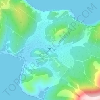
Name: Ayan topographic map, elevation, terrain.
Average elevation: 78 m
Minimum elevation: -3 m
Maximum elevation: 436 m
Thank you for supporting this site ❤️
Make a donation
Make a donation
Other topographic maps
Click on a map to view its topography, its elevation and its terrain.
Dzhugdzhur Mountains
Russia > Khabarovsk Krai > Ayano-Maysky Rayon
The coastal stretch of the range is populated by Japanese stone pine and Dahurian larch. Parts of the range occupied by the Okhotsk-Manchurian taiga ecoregion contain swathes of Jezo spruce up to elevations of 1,300 m.
Average elevation: 1,564 m