
Thank you for supporting this site ❤️
Make a donation
Make a donation
Birmingham topographic map
Click on the map to display elevation.
Thank you for supporting this site ❤️
Make a donation
Make a donation
About this map
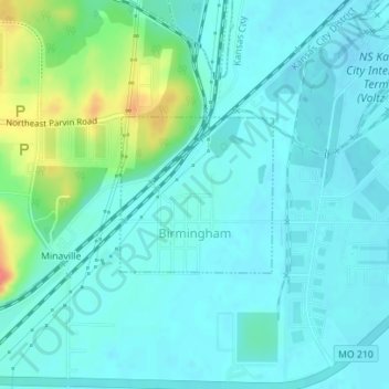
Name: Birmingham topographic map, elevation, terrain.
Location: Birmingham, Clay County, Missouri, United States (39.16214 -94.45715 39.17302 -94.44343)
Average elevation: 231 m
Minimum elevation: 219 m
Maximum elevation: 278 m
Thank you for supporting this site ❤️
Make a donation
Make a donation
Other topographic maps
Click on a map to view its topography, its elevation and its terrain.
Thank you for supporting this site ❤️
Make a donation
Make a donation
Kansas City, Clay County and St. Joseph Railroad
United States > Missouri > Clay County
Average elevation: 255 m
Thank you for supporting this site ❤️
Make a donation
Make a donation