
Lockhart Oil Field topographic map
Interactive map
Click on the map to display elevation.
About this map
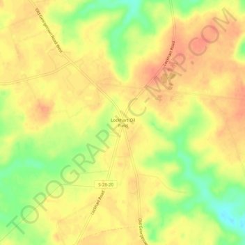
Name: Lockhart Oil Field topographic map, elevation, terrain.
Average elevation: 126 m
Minimum elevation: 96 m
Maximum elevation: 141 m
Other topographic maps
Click on a map to view its topography, its elevation and its terrain.
White Hills
United States > South Carolina > Kershaw County > Elgin
White Hills, Elgin, Kershaw County, South Carolina, United States
Average elevation: 97 m
Lugoff
United States > South Carolina > Kershaw County
Lugoff, Kershaw County, South Carolina, United States
Average elevation: 69 m
Camden
United States > South Carolina > Kershaw County
Camden, Kershaw County, South Carolina, United States
Average elevation: 68 m
Lake Wateree
United States > South Carolina > Kershaw County
Lake Wateree, Kershaw County, South Carolina, United States
Average elevation: 109 m
Lake Wateree
United States > South Carolina > Kershaw County
Lake Wateree, Kershaw County, South Carolina, United States
Average elevation: 76 m
Arrowwood
United States > South Carolina > Kershaw County
Arrowwood, Kershaw County, South Carolina, 29020, United States
Average elevation: 74 m
Woodland Forest
United States > South Carolina > Kershaw County > Lugoff
Woodland Forest, Lugoff, Kershaw County, South Carolina, 29078, United States
Average elevation: 65 m
Green Valley
United States > South Carolina > Kershaw County > Green Valley
Green Valley, Kershaw County, South Carolina, United States
Average elevation: 59 m