
Thank you for supporting this site ❤️
Make a donation
Make a donation
Piteå topographic map
Click on the map to display elevation.
Thank you for supporting this site ❤️
Make a donation
Make a donation
About this map
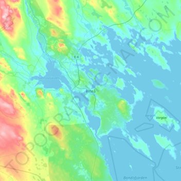
Name: Piteå topographic map, elevation, terrain.
Location: Piteå, Piteå kommun, Norrbotten County, 941 31, Sweden (65.15347 21.33003 65.47347 21.65003)
Average elevation: 32 m
Minimum elevation: -5 m
Maximum elevation: 228 m
Thank you for supporting this site ❤️
Make a donation
Make a donation
Other topographic maps
Click on a map to view its topography, its elevation and its terrain.