
Thank you for supporting this site ❤️
Make a donation
Make a donation
White Plains topographic map
Click on the map to display elevation.
Thank you for supporting this site ❤️
Make a donation
Make a donation
About this map
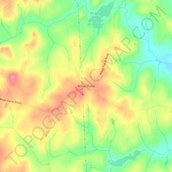
Name: White Plains topographic map, elevation, terrain.
Location: White Plains, Cherokee County, South Carolina, United States (34.97374 -81.75705 35.01374 -81.71705)
Average elevation: 200 m
Minimum elevation: 157 m
Maximum elevation: 241 m
Thank you for supporting this site ❤️
Make a donation
Make a donation
Other topographic maps
Click on a map to view its topography, its elevation and its terrain.
Blacksburg
United States > South Carolina > Cherokee County
Whitaker Mountain is partially in the northern corner of the town, with a summit elevation outside the town limits of approximately 1,169 ft (356 m).
Average elevation: 228 m