
Thank you for supporting this site ❤️
Make a donation
Make a donation
Bogis-Bossey topographic map
Click on the map to display elevation.
Thank you for supporting this site ❤️
Make a donation
Make a donation
About this map
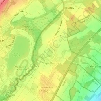
Name: Bogis-Bossey topographic map, elevation, terrain.
Location: Bogis-Bossey, District de Nyon, Vaud, 1279, Switzerland (46.34371 6.15752 46.36608 6.19489)
Average elevation: 468 m
Minimum elevation: 422 m
Maximum elevation: 507 m
Thank you for supporting this site ❤️
Make a donation
Make a donation
Other topographic maps
Click on a map to view its topography, its elevation and its terrain.