
Make a donation
Babuyan Island topographic map
Click on the map to display elevation.
Make a donation
About this map
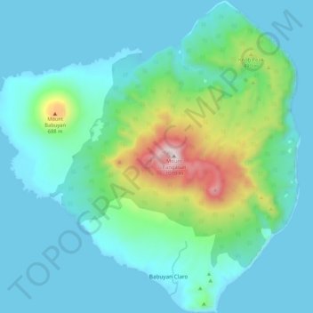
Name: Babuyan Island topographic map, elevation, terrain.
Average elevation: 185 m
Minimum elevation: 0 m
Maximum elevation: 1,061 m
Make a donation
Other topographic maps
Click on a map to view its topography, its elevation and its terrain.
Mount Pangasun
Philippines > Cagayan > Calayan
Babuyan Claro is a stratovolcano with an elevation of 843 meters (2,766 ft) and a base diameter of about 8 kilometers (5.0 mi) located in the center of Babuyan Island (also referred to as Babuyan Claro Island). It has four morphologically-fresh volcanic edifices: Mt. Cayonan in the south, Mt. Naydi and Mt.…
Average elevation: 688 m
Didicas Volcano
Philippines > Cagayan > Calayan
Didicas is topped with a lava dome with an elevation of 228 metres (748 ft) and a base diameter of 1,200 metres (3,900 ft) at sea level. It is at the southern end of the Luzon Volcanic Arc, and like all the volcanoes in the Philippines, is part of the Pacific ring of fire.
Average elevation: 7 m
Make a donation
Make a donation