
Thank you for supporting this site ❤️
Make a donation
Make a donation
Hollenburg topographic map
Click on the map to display elevation.
Thank you for supporting this site ❤️
Make a donation
Make a donation
About this map
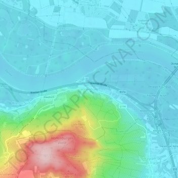
Name: Hollenburg topographic map, elevation, terrain.
Average elevation: 233 m
Minimum elevation: 182 m
Maximum elevation: 436 m
Thank you for supporting this site ❤️
Make a donation
Make a donation
Other topographic maps
Click on a map to view its topography, its elevation and its terrain.
Gemeinde Krems an der Donau
Österreich > Niederösterreich > Krems an der Donau
Krems liegt auf einer Höhe von 203 m ü. A., der tiefste Punkt im Gemeindegebiet sind die Steinplatten bei Hollenburg (189 m), der höchste liegt mit ca. (545 m) in der Nähe von Scheibenhof.
Average elevation: 310 m