
Thank you for supporting this site ❤️
Make a donation
Make a donation
Tranholmen topographic map
Click on the map to display elevation.
Thank you for supporting this site ❤️
Make a donation
Make a donation
About this map
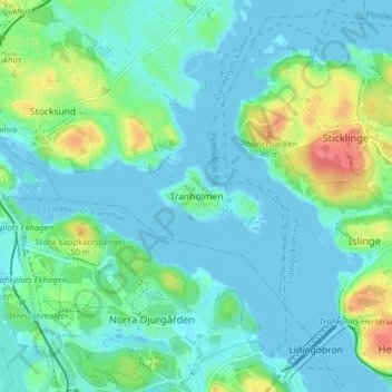
Name: Tranholmen topographic map, elevation, terrain.
Location: Tranholmen, Danderyds kommun, Stockholms län, 115 47, Sverige (59.35585 18.06600 59.39585 18.10600)
Average elevation: 13 m
Minimum elevation: -2 m
Maximum elevation: 57 m
Thank you for supporting this site ❤️
Make a donation
Make a donation
Other topographic maps
Click on a map to view its topography, its elevation and its terrain.