
Thank you for supporting this site ❤️
Make a donation
Make a donation
Jübar topographic map
Click on the map to display elevation.
Thank you for supporting this site ❤️
Make a donation
Make a donation
About this map
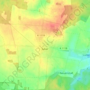
Name: Jübar topographic map, elevation, terrain.
Average elevation: 86 m
Minimum elevation: 59 m
Maximum elevation: 111 m
Thank you for supporting this site ❤️
Make a donation
Make a donation
Other topographic maps
Click on a map to view its topography, its elevation and its terrain.
Groß Wieblitz
Deutschland > Sachsen-Anhalt > Altmarkkreis Salzwedel > Salzwedel
Average elevation: 39 m
Thank you for supporting this site ❤️
Make a donation
Make a donation
Neu Wernstedt
Deutschland > Sachsen-Anhalt > Altmarkkreis Salzwedel > Kalbe (Milde) > Wernstedt
Average elevation: 49 m
Klein Chüden
Deutschland > Sachsen-Anhalt > Altmarkkreis Salzwedel > Salzwedel
Average elevation: 22 m
Klein Bierstedt
Deutschland > Sachsen-Anhalt > Altmarkkreis Salzwedel > Rohrberg
Average elevation: 52 m
Thank you for supporting this site ❤️
Make a donation
Make a donation
Thank you for supporting this site ❤️
Make a donation
Make a donation
Deutschhorst
Deutschland > Sachsen-Anhalt > Altmarkkreis Salzwedel > Ellenberg > Deutschhorst
Average elevation: 50 m