
Olde West Chester topographic map
Interactive map
Click on the map to display elevation.
About this map
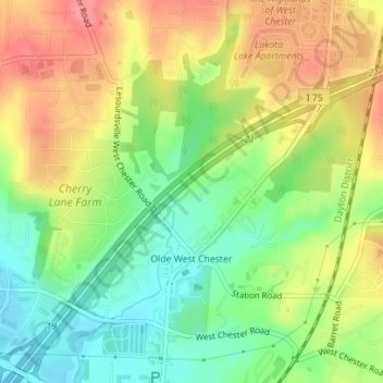
Name: Olde West Chester topographic map, elevation, terrain.
Average elevation: 227 m
Minimum elevation: 186 m
Maximum elevation: 272 m
Other topographic maps
Click on a map to view its topography, its elevation and its terrain.
Wetherington
United States > Ohio > Butler County > Wetherington
Wetherington, West Chester Township, Butler County, Ohio, United States
Average elevation: 261 m
Oxford
United States > Ohio > Butler County
Oxford, Oxford Township, Butler County, Ohio, 45056, United States
Average elevation: 279 m
West Chester Township
United States > Ohio > Butler County
West Chester Township, Butler County, Ohio, 45069, United States
Average elevation: 230 m
Astoria
United States > Ohio > Butler County
Astoria, Madison Township, Butler County, Ohio, United States
Average elevation: 263 m
Middletown
United States > Ohio > Butler County
Middletown, Butler County, Ohio, United States
Average elevation: 216 m
West Chester
United States > Ohio > Butler County > West Chester
West Chester, West Chester Township, Butler County, Ohio, 45069, United States
Average elevation: 231 m