
St-Lambert topographic map
Interactive map
Click on the map to display elevation.
About this map
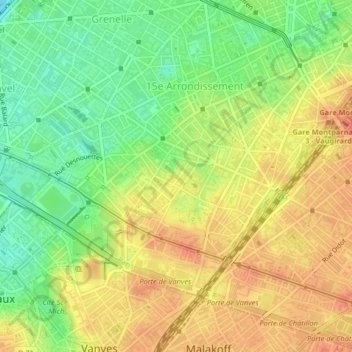
Name: St-Lambert topographic map, elevation, terrain.
Average elevation: 55 m
Minimum elevation: 26 m
Maximum elevation: 79 m
Other topographic maps
Click on a map to view its topography, its elevation and its terrain.
Paris 8e Arrondissement
Frankreich > Île-de-France > Paris
Paris 8e Arrondissement, Paris, Île-de-France, Metropolitanes Frankreich, 75008, Frankreich
Average elevation: 52 m
Enfants Rouges
Frankreich > Île-de-France > Paris
Enfants Rouges, 3e, Paris, Île-de-France, Metropolitanes Frankreich, 75003, Frankreich
Average elevation: 51 m
Amérique
Frankreich > Île-de-France > Paris
Amérique, 19e, Paris, Île-de-France, Metropolitanes Frankreich, 75019, Frankreich
Average elevation: 82 m